Why Other Mapping Platforms Don't Cut It Anymore
Table of contents:
Note: This post was written in 2015. The writing quality is not that great and I won’t try to improve it as well. This was republished from another platform for pure historic value of being my first blog post ever. My opinions and thoughts on the topics shared in this post might have changed.
A Recap on the discovery of Openstreetmap and the two days in Mapbox.
Maps were something that I was really good at! Or something I didn’t know much about until I bumped into Openstreetmap (OSM). I thought I was an expert in maps as I was using Google maps application. Keep it updated to the latest version, and i was doing only that. Come on.. I was working in Bangalore - A place I knew nothing about initially. I traveled less but when I did, I was using Google maps to tell me how to go to places. I didn’t know from where these guys where getting the data about everything. I mean, who cares right? I just wanted to go to those places. I let Google do all the work for me, And I was fine with it too! That’s when I got to know about Openstreetmap - which is an open source project.
Openstreetmap - It was nothing like the other open source projects. You contribute map data instead of the codes (Most of the part I guess). Wait… what? Map data? How do I get it? From where do I get it? Should I be copying from Google Maps…? I had no idea! My mind was full of questions. As days passed, I was learning a lot about maps. Got to know a lot on what kind of data will be uploaded to openstreetmap, and the details that completes a map. I didn’t do much after that though. It was just another awesome project that I bumped into like many other.
I applied for the job, got acknowledged by Sajjad. We talked a lot about what they were working on in Mapbox. That’s when i got to know about the connection of Mapbox and Openstreetmap. I wanted to know more about Openstreetmap!
Luckily my friend who had a good knowledge on OSM helped me out with it. And in the process I got to know about JOSM (A cross-platform editor for openstreetmap written in Java), the most used tool by OSM contributors!
As planned earlier, I had the call with Sajjad where we talked about what my goals and passions were and reason for applying this job. I liked where the discussion was heading and how the company and I shared the same interests (Open source!!). After that I started mapping in a pretty small way…. Started using OSM tracker for Android - which is an app on Google play store to track the GPS co-ordinates of your journey using your smartphone GPS. Went to some of the places in my village and got the raw data as .gpx files. Started adding the data and uploaded the same to the Openstreetmap.org. My first meaningful contribution to an open source project!
Discussions were going on in mails and I was contacted by Arun from Mapbox and he gave me a much needed idea on what my role will be if i were to work full time on Mapbox. I learned a lot through the discussions and Arun was always there to help me with the answers for my queries. That was when Earthquake happened in Nepal and later in some parts of India. That is also the time when I knew the value of crowd sourcing and power of the Openstreetmap community. They updated the areas affected by earthquakes in two weeks or so. I was amazed by the sheer power Openstreetmap community. The changes made by them was significant compared to before and after the disastrous earthquake. This was amazing according to me because I have never seen anything like that till then. I was busy with my work that I have in Tech Mahindra (TechM) at this time. And because of this, I couldn’t be a contributor among the thousands who helped update the maps in Nepal post earthquake. Later I started working on Agra road network and completed a task and uploaded the same to OSM. It was a wonderful feeling and experience.
Conversations were happening with me and Arun through mails quite often and I was getting closer and closer to OSM and Mapbox. It was at this time a call was arranged with Alex Barth who leads the data team in Mapbox. We had a discussion about what I did in TechM (the company that I work in currently), and how the clients of Mapbox uses the maps. Everything was interesting and I got to know much more about the company. After some days, I was called to Mapbox office for two days sprint.
The meetup
Day-1
It was only 30mins travel from my room in Bangalore, so that was not a big issue for me. Reached Mapbox office at 8.35am or so. Nobody except Shravan was in the office. Met him and was on to work right away. We started tracing out buildings in Gangtok and after a while came Arun. Finally got to meet him. After everyone was in the office, we started to plan to go out for surveying parts of Indiranagar. For this we used Fieldpapers which is a website that helps us with Hand-drawn graphic to represent making a Field Papers atlas. It’s like, we will be taking the print out of an area, taking the survey and mark the changes in the paper. After the changes are marked, we can scan the sheet and upload the picture file to https://www.fieldpapers.org and get it aligned properly with OSM maps in JOSM. The area to be covered was split into two namely A1 and A2. A1 containing 4 people and A2 containing the other 4 people. That was further split into two. Two for covering the Point of Interests (POI’s) and two people covering the trees and levels of the buildings. This is easier said than done. We had to go to each streets and crosses in the area to get all of this data and Me and Ruth from Mapbox was one team. Our job was to get the Point of Interests (POI’s) of the areas in A2.
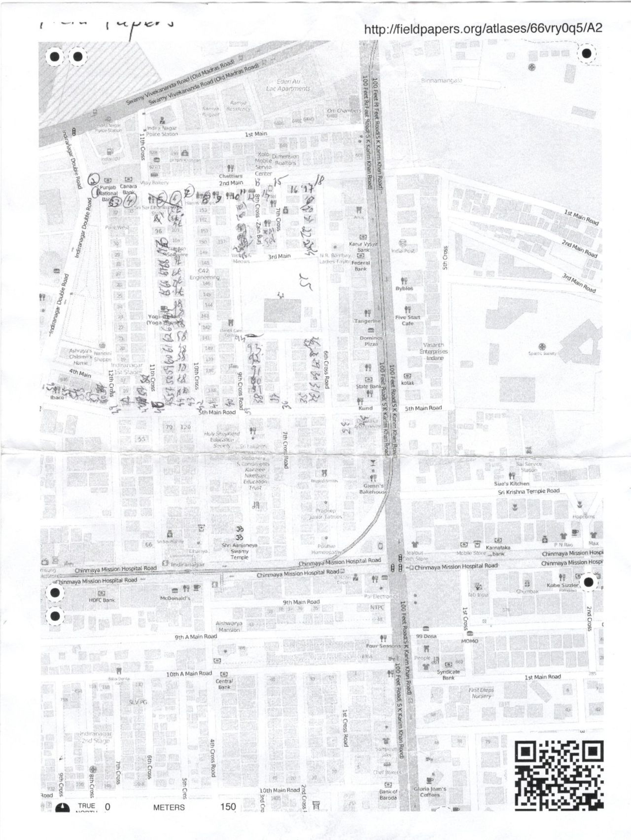
After the data was collected, which was a tiresome walk in the sun but fun at the same time we came back to the office so that we can start uploading the changes to OSM. As the fieldpapers.org aligning mechanism was not working as it’s suppose to be, we had this fun time learning to do the same in JOSM manually. Once the page was aligned exactly on top the OSM maps, we started uploading the changes to OSM. After a long period of continuous effort we all were able to upload the changes to OSM which had the names of all the shops and levels of the buildings and the trees that was there in the area. Yes.. trees!!! We had an awesome time after the work with the team talking and playing Jenga. Sajjad was playing this awesome song through his phone which i got to know was || Kygo – Firestone || which became one of my favorite song soon after.
Day-2
The second day started with Arun teaching what all is that we do in Mapbox as a Data analyst (which is the designation that I applied for). Learned a lot about how to manage the different kind of issues that come in daily. After that, Arun was showing the map that he have created about the Lakes in the south Bangalore with the help of OSM data. I was surprised and amazed to know that all the lakes were inter-connected! All the data that was in the maps was showing how the Bellandur lake was the meeting point where all the polluted and dirty water was flowing in. This partially explained why the lake is so polluted and how the fire emerged from the lake and the reason for the foam that was seen above the lake water like a layer. Everything proving the real power of crowd sourcing and opens source once again. After learning how to handle various types of issue that we may face on a daily basis, I knew it was time to call it a day. The two days went just like that with lots of fun and lots of new things learned. Thanks to Mapbox, I learned a lot on how you can trust to use an open source project as a base layer upon which a business can be made with the help of crowd sourcing and open source community it will offer.
Have thoughts or feedback regarding my post/writing? DM me on Twitter @unsungNovelty.